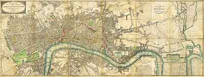
London Map of 1804
I’ve mentioned this website here before and I’m sure well-traveled authors already know of it, but I recently had reason to revisit mapco.net again to find a pre-Regency map of London and wanted to share my find.
The next stories in the affairs of Charlotte House and Jane Woodsen are set in London and take place over a wide area from Grosvenor Square, Miss House’s home, to the East End and the Isle of Dogs and the East India Docks, an unsavory location for such gentlewomen to be I know, but a lot of fun to write. Our Mutual Friends, the sequel to My Particular Friends, obviously has a nod to Mr. Dicken’s Our Mutual Friend, so expect something quite different to the Bath adventures of Charlotte and Jane. The river plays a large part of the story and there’s a nice website dedicated to the river here.
At mapco.net, I found the 1804 Wallis map of London, which is perfect for helping me map my story. It’s a huge map and for my own use, I’ve assembled it into a 16,800-by-6,332 pixel PhotoShop document. I include it here as a more reasonable 5,000-by-1,885 pixel jpg. Click the thumbnail above to see the larger map, or better yet, visit http://mapco.net/wallis1804/wallis06.htm to see the entire map.
You can also click here to see the map in a new window.
This map is quite useful because it strips London of all the Victorian improvements that define the city and the Thames as we know it today. The Victoria and Chelsea embankments designed by Joseph Bazalgette are in the future. Somerset House is still by the river so that strange little arch visitors see while walking along the embankment makes sense.
In the same way, Traitor’s Gate then made sense as an entrance to the Tower of London from the Thames, instead of being the weird affectation it is now.
Buckingham Palace was just the Queen’s Palace then. George III bought Buckingham House in 1761 for Queen Charlotte. It wasn’t until George IV (the former Prince Regent), that it began to be transformed into the Buckingham Palace that we know today (unfortunately at the cost of Carlton House).
Sharp-eyed map readers will also note the absence of Regent’s Park and Regents Street; they were yet to be built. The Prince Regent intended the street to connect Regent’s Park with Carlton House. Carlton House Terrace now stands there. The above Lucy Worsley documentary Elegance and Decadence examines the creation of Regent Street.

The map also shows the medieval London Bridge still standing, although by this time it did not have the grandeur of the drawing above. For one thing, the drawbridge had been made into a permanent span and all the building has been torn down in the eighteenth century. The medieval bridge would be demolished in 1831 after the New London Bridge was completed, and that bridge, of course, now bridges Lake Havasu in Arizona. The current London Bridge was completed in 1973. Dan Cruikshank’s The Bridges That Built London may be of further interest.
The neo-Gothic Houses of Parliament as we know them today were not yet built. Most of the Palace of Westminster was destroyed in a fire in 1834. Westminster Hall is the oldest surviving part of the palace.
This map also shows the New Commercial Road to the recently completed West India Docks, although in truth, navvies were still building Commercial Road. The docks have a significant role in Our Mutual Friends.
A further boon to historical fiction writers is the chart showing hackney coach fares and the labeling of the numerous wharves and quays along the Thames. Curiously, I just learned while reading Peter Ackroyd’s Thames: A Biography, the difference between a wharf and a quay, At the time of Elizabeth I, there were twenty “legal quays” —places where ships could be legally loaded and unloaded, whereas wharves were reserved for barge traffic. That distinction, however, fell apart but in general, quays are bigger than wharves.
All this is in way of saying that I am actively writing Our Mutual Friends and I promise the first chapter in a few days as proof and as a commitment to finish it.


